Artikel baru | Between Natural and Anthropogenic Coastal Landforms: Insights from Ground Penetrating Radar and Sediment Analysis
Dan madingnya sudah terbit.
Berikut tautan artikel kami terbaru yang telah terbit di Journal Applied Sciences. Judul: Between Natural and Anthropogenic Coastal Landforms: Insights from Ground Penetrating Radar and Sediment Analysis. Penulis: Yuniarti Ulfa (ITB), Teoh Ying Jia (USM), Ahmad Munim Che Yaziz (USM), Dasapta Erwin Irawan (ITB), dan Deny Juanda Puradimaja (ITB).
Di sini kami mencoba membedakan antara kawasan pantai di Penang yang masih alami dengan kawasan pantai yang telah mendapatkan sentuhan rekayasa manusia. Kami mendeteksi dampak antropogeniknya menggunakan GPR.
Hasilnya, rekayasa manusia ini jelas terlihat dampaknya di bawah permukaan. Salah satunya adalah adanya jejak unsur logam yang di keluar dari sistem air kotor. Jejak ini akan terlihat meskipun sumber pencemarannya sudah dihentikan.
Artikel ini adalah kerjasama antara USM dan ITB. Penulis pertama adalah mahasiswa S3 Prodi Teknik Geologi ITB, Yuniarti Ulfa.
Tapi ya begitulah. Sebagian orang menilai ini kemenangan, padahal ini adalah kekalahan.
Kenapa? Karena perlu mahal untuk lulus.
Abstrak
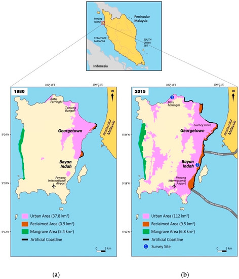
Both natural and anthropogenic coastal landforms characterize Penang Island. As years have passed it is a challenge to differentiate the genuineness of landmasses created by natural geological formations or by coastal reclamation projects. An account is given of the environmental impact of solid wastes used for reclaiming land in coastal areas of Penang and of the impact of a major sewage outfall in the western channel. Leaching of heavy metals was shown to be one of the main sources of contamination from solid wastes. This paper presents eight lines of ground penetrating radar (GPR) surveys and sediment analysis to identify the anthropogenic interventions that shaped the urban landscape of Penang Island by excavations, filling, and embankment construction along the coastline and differentiate it from the natural one. The surveys were implemented in two locations, the Batu Ferringhi area, representing the natural coastline, and Persiaran Bayan Indah (the Queensbay Mall area), representing the anthropogenic coastal landform. The apparent depth of penetration that was achieved using a 250-MHz antenna is limited (less than 5 m). The results show between natural and anthropogenic sediment recorded different radar facies. In complement mode, mean grain size distribution, sorting, skewness, and kurtosis graphics of sediment samples from both sites correspond with the GPR data. This technique can likely be applied to the developing coast, where natural and anthropogenic coastal landform data is incomplete, considering future coastline development.